Uganda — OND 2026 flood trigger: revised analysis and design options
A design plan, not yet a trigger. New country documents (impact records, severity classifications, community flood-risk maps) shared in Aug 2026 sharpen the August drought & flood analysis into a concrete question: what would an anticipatory-action flood trigger for the Oct–Dec 2026 season look like, targeting only Severity 3+ locations, with a few days of lead time, in places where this season's flooding is predictable enough to act on — and with the funds spent before the season ends.
The season this trigger would run in. The August 2026 SEAS5 issuance forecasts Oct–Dec at the 91st–98th rainfall percentile across Uganda — the wettest OND forecast in SEAS5's own history — with El Niño and a positive IOD both active, the 2015/2023 configuration. The existing analysis shows wettest-quintile ONDs flood significantly more (Mann-Whitney p = 0.018), and Eastern region's flood extent has run near record levels all 2026 on stored water alone. A trigger designed now would be activated into a season with unusually high prior odds — which is exactly the situation the funding constraint (spend by end of season) wants.
1 · What the new documents contain #
| Document | What it is | What it contributes here |
|---|---|---|
| El Niño Impact in Uganda 2023–2025 (4 pp, for the 4 Jun 2026 OPM high-level meeting on EW/AA) | Event-by-event impact retrospective: 2024 the worst year on record (78,000+ displaced, 413,000+ affected); Rwenzori floods Aug–Sep 2024 (~44,400 affected, ~25,400 displaced); Bulambuli landslides Nov 2024 (49+ deaths); Mt Elgon Aug 2025 (20 deaths, 113 missing); Kampala flash floods Mar 2025. | The impact geography: Mt Elgon and Rwenzori sub-regions dominate deaths and displacement. Confirms past AA precedent (URCS flood EAP activated Nov 2023 via IFRC DREF). |
| Emerging Risk: disaster displacement and the 2026 El Niño outlook (UHF strategy note, Aug 2026) | JIAF-informed severity read: provisional intersectoral Severity 3 at verified sites in Kasese and Ntoroko (tier A); Bulambuli, Kween, Bukwo, Bududa in high-readiness (tier B); Bundibugyo, Bunyangabu, Manafwa, Namisindwa, Sironko as conditional monitoring (tier C). Explicitly recommends a forecast-triggered anticipatory-action window with an agreed trigger matrix (DMS-MWE rainfall warnings, river thresholds, soil/slope indicators) and 24–72 h release financing. | The Severity 3+ constraint made operational: which districts qualify today, which only after verification. Also the institutional ask this trigger design answers. |
| IOM DTM: affected people by district (xlsx, Oct 2023 – Oct 2025, sourced to 10 published DTM EET reports) | District-level flood/landslide affected counts per reporting round. Largest: Kasese 200,000 (Nov–Dec 2024); Pallisa 49,000 and Katakwi 29,735 (Sep–Oct 2025); Ntoroko 30,224 (Aug 2024); Otuke 13,560 (Sep–Oct 2024); Moyo 21,091 (Oct–Nov 2023). | A second impact record alongside EM-DAT — finer-grained and more recent. Trigger validation requires exactly this (impact record + observational record, not one or the other). |
| URCS/FAO flood-risk maps (Dec 2023, "10 districts" — 9 unique maps; one page is a duplicate of Mbale, Sironko appears missing) | Community-validated hotspot maps for Bulambuli, Butaleja, Bundibugyo, Kasese, Katakwi, Manafwa, Mbale, Ntoroko, Namisindwa: past flood events, elements at risk (schools, health facilities, boreholes), proposed evacuation centres and routes. | Sub-district targeting: once a district trigger is activated, these maps say which communities and facilities the money goes to. Also an implicit district shortlist someone already agreed on. |
| FAO/OPM/DRC/UNHCR EWS & AA needs assessment, refugee-hosting districts (preliminary, Jan 2026) | 92-respondent survey across 13 refugee-hosting districts: EWS coverage weak, fragmented, rarely reaching households; highest multi-hazard risk in Kiryandongo, Madi-Okollo, Terego, Yumbe, Lamwo; flood exposure flagged in Kiryandongo, Adjumani, Obongi; literacy, network and language the top dissemination barriers. | Mostly a caution: in refugee-hosting districts the last mile of any warning is weak, so trigger lead time must budget for slow dissemination. These districts are drought/conflict-dominated and mostly not Severity 3+ flood locations — largely out of scope for this trigger. |
2 · What this revises in the analysis #
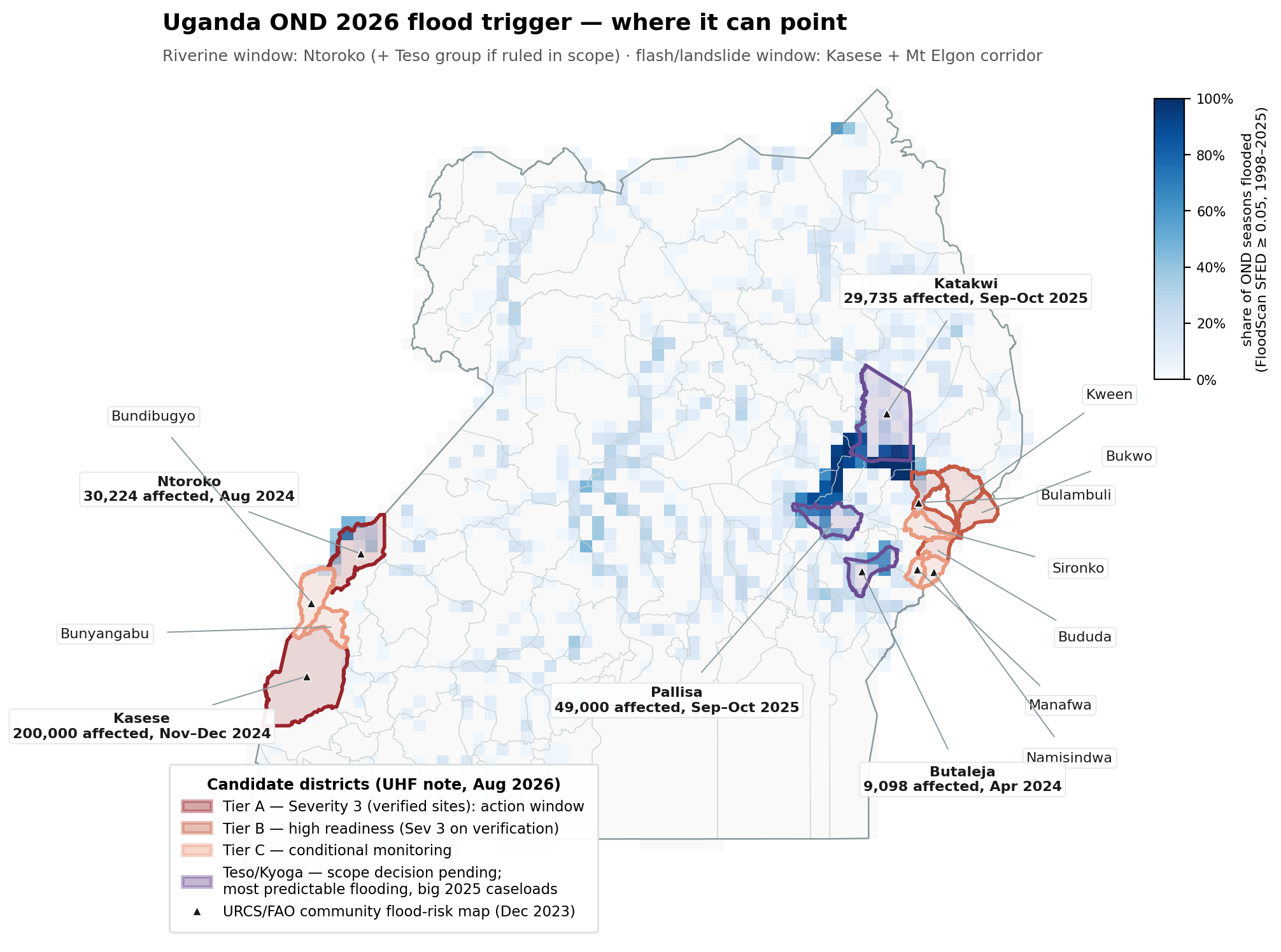
- From extent to impact. The existing analysis showed FloodScan flood-extent recurrence concentrating in the Teso/Lake Kyoga wetlands while EM-DAT impacts concentrate in Kasese and the Mt Elgon corridor. The DTM record confirms and sharpens this: the biggest recent caseloads are Kasese, Pallisa, Katakwi, Ntoroko, Otuke — a mix of both regimes. A trigger indexed on flood extent alone would systematically miss the deadliest locations.
- The Severity 3+ constraint binds hard. Only Kasese and Ntoroko carry (provisional, site-level) Severity 3 today. The Teso/Kyoga wetland districts — where flooding is most predictable and recent caseloads are large — are classified only as "trigger-dependent Severity 2–3, requires verification" in the UHF note. The most forecastable flooding and the currently eligible locations only partially overlap; the design has to face that tension rather than average over it (options and an explicit decision below).
- Sub-district targeting exists now. The URCS/FAO maps mean an activation does not stop at a district name: hotspot communities, at-risk facilities and evacuation routes are pre-identified for 9 of the candidate districts.
- Two-track funding logic. The UHF note separates response for verified current needs from forecast-triggered AA. This page concerns only the second track — which means the trigger does not need to prove current severity; it needs to anticipate flooding in locations already classified 3+.
- Validation data improved. DTM gives ten dated impact observations across 2023–2025 at district level to backtest against, in addition to EM-DAT's coarser event list.
3 · Where a trigger can point #
Candidate areas, scored against the three requirements (Severity 3+, predictable this season, meaningful lead time possible):
analysis/uga_flood_trigger_map.py.| Area | Severity status (UHF note) | Flood regime | Predictability | Recent impacts (DTM/EM-DAT) | URCS map |
|---|---|---|---|---|---|
| Ntoroko (Semliki lowlands) | Tier A — Sev 3 verified sites | Riverine/lakeshore (Semliki river, Lake Albert flats) — slow-onset, recurrent | Best of the eligible set — riverine, forecastable discharge, wetland signal visible to FloodScan | 30,224 affected Aug 2024; 13,776 Oct–Nov 2023; 54,000+ affected Aug–Sep 2024 (UN) | Yes |
| Kasese (Nyamwamba/Mubuku/Nyamugasani) | Tier A — Sev 3 verified sites | Flashy mountain rivers off the Rwenzoris — fast-onset riverine/flash | Moderate — short catchment response; needs short-range rainfall or high-frequency gauge forecasts, not seasonal products | 200,000 affected Nov–Dec 2024 (DTM); 19,508 May 2024; repeated 2023–25 | Yes |
| Mt Elgon corridor (Bulambuli, Bududa, Sironko, Manafwa, Namisindwa) | Tier B/C — readiness/monitoring, Sev 3 on verification | Landslides + flash floods on saturated slopes | Weakest — landslide timing is not forecastable at useful precision; rainfall proxy only, high false-alarm rate; invisible to 9-km FloodScan | Bulambuli Nov 2024: 49+ deaths, 12,000+ displaced; Aug 2025: 20 deaths, 15,000 affected | Yes (4 of 5) |
| Teso/Kyoga wetlands (Katakwi, Pallisa, Butaleja; also Otuke, Apac) | Not tiered — "lakeshore: trigger-dependent Sev 2–3, verify" | Wetland-extent riverine flooding — the most recurrent regime in the country (parts flood every OND) | Highest — but eligibility under the Sev 3+ rule is unresolved | Pallisa 49,000 + Katakwi 29,735 affected Sep–Oct 2025; 2007 Teso and Dec 2019 among worst EM-DAT events | Yes (Katakwi, Butaleja) |
The events a trigger must catch — and how they flooded #
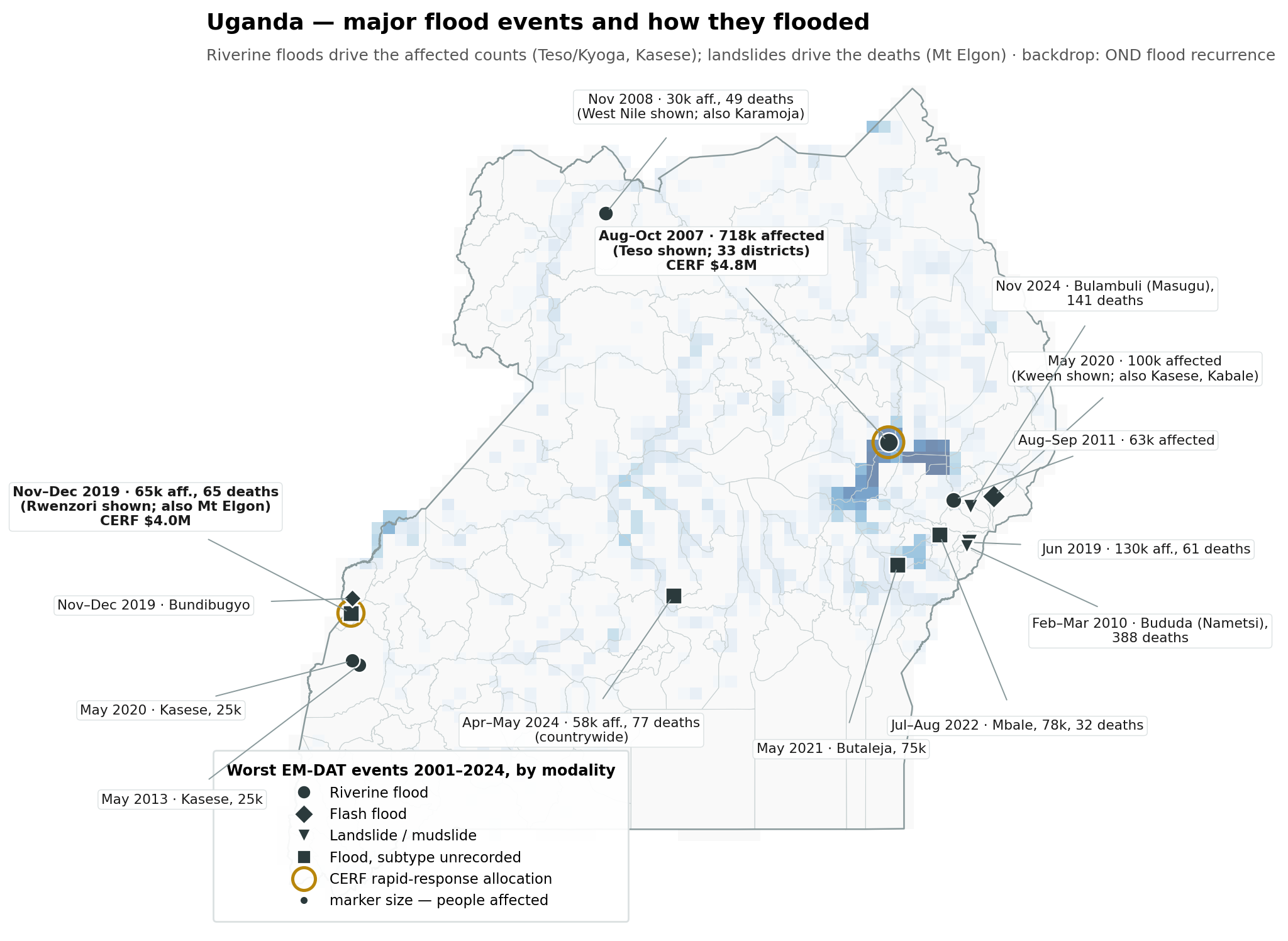
Trawling EM-DAT's full Uganda record (47 flood and wet mass-movement events, 2001–2024) and the CERF allocations dataset (HDX) gives the historical target list, with a clear modality split. Riverine floods drive the affected counts: the Aug–Oct 2007 Teso/Kyoga floods are the biggest event on record (718,000 affected) and Kasese's Nyamwamba/Mubuku rivers recur (May 2013, May 2020, ~25,000 each). Landslides drive the deaths, all on Mt Elgon: Bududa Feb–Mar 2010 (388), Bulambuli Nov 2024 (141), Bududa Jun 2019 (61). Flash floods sit in between — Mbale Jul–Aug 2022 (78,000 affected, 32 deaths), Kween/Kasese May 2020 (100,000 affected), Bundibugyo Nov–Dec 2019. And there are two CERF rapid-response precedents, both for the trigger's exact target seasons and areas: ~$4.8M in Oct 2007 for the Teso riverine floods, and ~$4.0M in Jan 2020 for the Nov–Dec 2019 Rwenzori/Elgon floods and landslides — the latter an OND season with a strong positive IOD, the closest analogue to the season this trigger would run in.
analysis/uga_flood_events_map.py.| Event | Modality (EM-DAT) | Where | Impact | CERF |
|---|---|---|---|---|
| Aug–Oct 2007 | Riverine | Teso/Kyoga + North (33 districts named) | 718,045 affected, 29 deaths — worst on record | $4.8M RR (Oct 2007) |
| Nov–Dec 2019 | Flood (unrecorded) + flash | Rwenzori + Mt Elgon sub-regions | 65,250 + 6,000 affected, 65 + 36 deaths | $4.0M RR (Jan 2020) |
| Jun 2019 | Landslide | Bududa, Sironko, Mbale, Butaleja | 129,953 affected, 61 deaths | — |
| May 2020 | Flash + riverine | Kween, Kasese, Kabale | 100,000 + 25,000 affected | — |
| Jul–Aug 2022 | Flood (unrecorded; flash per reports) | Mbale, Kapchorwa, Sironko, Bulambuli | 78,338 affected, 32 deaths | — |
| May 2021 | Flood (unrecorded) | Butaleja + Northern region | 75,000 affected | — |
| Aug–Sep 2011 | Riverine | Elgon foothills + scattered | 63,075 affected, 27 deaths | — |
| Apr–May 2024 | Flood (unrecorded) | Countrywide | 57,804 affected, 77 deaths | — |
| Nov 2024 | Landslide | Bulambuli (Masugu) + Elgon | 30,022 affected, 141 deaths | — |
| Feb–Mar 2010 | Landslide | Bududa (Nametsi), Butaleja | 12,795 affected, 388 deaths — deadliest | — |
Decision needed from the working group before design starts: are Katakwi/Pallisa/Butaleja in scope? They are the most predictable flooding with large 2025 caseloads, but are not currently classified Severity 3+. If the country team can verify severity there in September (the UHF note's own framework allows "trigger-dependent" classification), they become the strongest trigger candidates on the board. If not, the mechanism is Ntoroko + Kasese, with the Elgon corridor as a readiness-only window.
4 · Trigger options #
All options follow the team's standard shape: return-period-calibrated thresholds, staged windows by lead time (readiness releasing only mobilisation funds ~5%, action releasing the bulk), forecast OR'd with an observational backstop. Given the funds must move this season, thresholds should target a low rarity — roughly 1-in-2 to 1-in-3-year — rather than the usual 1-in-5; in a forecast-record-wet season that puts the combined annual activation probability high, by design.
Option 1 — GloFAS ensemble discharge at selected reaches (riverine core) #
GloFAS ensemble forecast discharge exceeding the ~2–3-yr return-period threshold with ≥60% of members, at reaches for the Semliki (Ntoroko), the Kasese rivers, and — if in scope — the Teso/Kyoga inflows and Manafwa river (Butaleja). Action window at 3–7 days lead; the same reaches at 10–15 days serve as the readiness window. This is the team's most-used flood pattern (Nepal, Chad, Bangladesh, South Sudan, Nigeria readiness).
Designed for events like: Teso Aug–Oct 2007 (the CERF-responded 718k event) and Katakwi Sep–Oct 2025 — via the Akokorio point. After the verification below: not the Ntoroko/Semliki events, not Butaleja/Manafwa, not the Kyoga Nile itself, and blind to the Elgon landslides and the Nyamwamba floods.
Verified against GloFAS's own skill layers (1 Sep 2026) — both metrics, because they answer different questions: CRPSS lead time says how far ahead the forecast beats climatology, while the hydrological model performance against the station record (modified KGE and its correlation component) says whether the model reproduces the river at all. A long CRPSS lead over broken hydrology is an artifact, not a trigger.
| GloFAS point | Trigger river | CRPSS>0.5 lead | KGE | corr | bias | Verdict |
|---|---|---|---|---|---|---|
| Akokorio at Uganda Gauge (calibrated, 22-yr record) | Teso — Katakwi/Amuria | 14 d | 0.11 | 0.65 | 1.68× | usable timing is right; the wet bias means thresholds must be set in model space (reforecast RPs), never on observed discharge |
| Kyoga Nile at Masindi Port (calibrated, 28-yr) | Kyoga outflow | 15 d | −0.83 | 0.21 | 2.50× | not usable the long CRPSS lead is a slow lake-outflow signal beating climatology, on hydrology the model gets wrong (corr 0.21) |
| Kapelebyong | Akokoro, north Teso | 12 d | no station evaluation | unvalidated model self-skill only | ||
| Mpologoma at Budumba | drains Pallisa/Butaleja | 4 d | no station evaluation | unvalidated, short lead | ||
| Magoro/Apapi | Katakwi east | 2 d | no station evaluation | not usable | ||
| Semliki | Ntoroko | 0 d | no station evaluation | not usable | ||
| Manafwa at Butaleja (uncalibrated, 25-yr) | Butaleja | 0 d | −10.6 | 0.37 | 12.6× | not usable |
| Kasese rivers (Nyamwamba, Mubuku) | no reporting points at all | absent | ||||
Net: GloFAS offers exactly one defensible trigger point in Uganda — Akokorio, for a Katakwi/Teso window (decent correlation, two weeks of forecast skill, thresholds derived from the reforecast climatology). Everything else fails on hydrology, is unvalidated against any station, or does not exist. Source: GloFAS map service ForecastSkill + HydrologicalModelPerformance layers (CRPSS lead, modified KGE with corr/bias components, station records to ~34 years).
Option 2 — Google Flood Hub / GRRR gauge consensus (small-river coverage) #
Google's operational river gauges publish forecasts to 7 days with pre-computed 2/5/20-yr warning levels, and cover smaller rivers than GloFAS resolves. A multi-gauge consensus (N of M gauges over their warning level simultaneously — the design Nigeria's 2026 revision adopted after single-gauge logic proved fragile) across the gauges in each target area.
Designed for events like: the small-river floods GloFAS under-resolves — the Nyamwamba through Kasese (May 2013, May 2020, Nov–Dec 2024's 200k-affected event), the Nabuyonga through Mbale (Jul–Aug 2022), Kween May 2020 — plus the same large riverine set as Option 1 where gauges exist. Still blind to the Elgon landslides.
Option 3 — Short-range extreme-rainfall trigger (flash-flood / landslide corridor) #
For Kasese and (if funded) the Elgon corridor, where discharge products are least reliable: ECMWF ensemble 3-day accumulated rainfall over the upslope catchment exceeding its ~3-yr return-period value, at 1–5 days lead, OR'd with a UNMA/DMS-MWE heavy-rainfall advisory for the sub-region. Rainfall is a proxy — antecedent saturation does the real work in landslides — so pair with a simple antecedent-wetness qualifier (e.g. previous 30-day rainfall percentile) to cut false alarms.
Designed for events like: the ones no discharge product reaches — the Elgon landslides (Nametsi Feb–Mar 2010, Bududa Jun 2019, Bulambuli/Masugu Nov 2024, Mt Elgon Aug 2025), Bundibugyo's Nov–Dec 2019 flash floods, Kween/Kasese May 2020. Not aimed at the slow wetland floods (Teso 2007, Butaleja) — those belong to Options 1–2.
Option 4 — Observational backstop (guarantees the money moves) #
An observational trigger that activates on flooding already underway: FloodScan
SFED exposure over threshold in the target districts (Uganda is not yet in the
team's daily flood-exposure pipeline — adding it is a one-line
init_iso3 job), a DTM EET report confirming displacement over an
agreed count, or a river gauge over its danger level. Zero lead time, so it
funds early response rather than anticipation — but under a
spend-by-season-end constraint it is the safety net that converts a forecast
miss into a fast activation instead of unspent funds.
Designed for events like: all of the above, once flooding is underway — the FloodScan leg sees the wetland/riverine events (Teso 2007, Butaleja 2021, Katakwi–Pallisa 2025, Ntoroko), the report-based leg catches what the satellite misses (every Elgon landslide, the flash floods). The safety net, not the anticipation.
Which option is built for which event #
The same mapping as a matrix, across the major historical events. This is designed-for coverage — which window each event type falls under — not a claim that the trigger would surely have activated; whether it actually would have is exactly what the backtest in section 5 exists to establish. core = the event type the option is built around; weak = in scope but where the indicator is least reliable (or, for the backstop, only via the report-based leg); — = not designed for it.
| Event | Modality | 1 · GloFAS | 2 · Flood Hub | 3 · Rainfall | 4 · Backstop |
|---|---|---|---|---|---|
| Aug–Oct 2007 · Teso, 718k (CERF) | Riverine | core | core | — | core |
| Nov–Dec 2019 · Rwenzori + Elgon (CERF) | Flash + mixed | weak | core | core | weak |
| Sep–Oct 2025 · Katakwi–Pallisa (DTM) | Riverine/wetland | core | core | — | core |
| Aug 2024 · Ntoroko/Semliki (DTM) | Riverine | —† | core | — | core |
| Nov–Dec 2024 · Kasese, 200k (DTM) | Riverine/flash (Nyamwamba) | weak | core | core | weak |
| May 2013 / May 2020 · Kasese | Riverine/flash (Nyamwamba) | weak | core | core | weak |
| May 2020 · Kween, 100k | Flash | weak | core | core | weak |
| Jul–Aug 2022 · Mbale, 78k | Flash (Nabuyonga) | weak | core | core | weak |
| May 2021 · Butaleja, 75k | Riverine (Manafwa r.) | weak† | core | — | core |
| Aug–Sep 2011 · Elgon foothills, 63k | Riverine | weak† | core | weak | core |
| Feb–Mar 2010 · Nametsi, 388 deaths | Landslide | — | — | core | weak |
| Jun 2019 · Bududa, 130k | Landslide | — | — | core | weak |
| Nov 2024 · Bulambuli/Masugu, 141 deaths | Landslide | — | — | core | weak |
| Apr–May 2024 · countrywide, 77 deaths | Mixed | weak | weak | weak | core |
| Nov 2008 · West Nile + Karamoja, 30k | Riverine | — | — | — | — |
† Downgraded after checking GloFAS's own skill layers (see Option 1): Semliki 0 days of skillful lead, Manafwa at Butaleja 0 with KGE −10.6 (Mpologoma at Budumba 4 days, unvalidated), no upper-reach points in the Elgon foothills. The Teso/Katakwi rows stay core on the strength of the Akokorio point alone — the Kyoga Nile point's long lead fails the hydrology check (corr 0.21) and does not count.
Two things the matrix makes plain. First, no single option covers the record: the riverine column and the landslide rows are disjoint, which is the case for the two-window recommendation below. Second, coverage assumes the proposed geographic scope — the Nov 2008 West Nile/Karamoja floods and parts of the Apr–May 2024 countrywide event fall outside every proposed window, whatever the indicator. That is a scope choice to make with eyes open, not an oversight: a trigger for everywhere is a trigger for nowhere.
Recommended shape #
A mixed-basis mechanism with windows split by space (the two regimes need different indicators) and staged by time within each:
- Riverine window (Ntoroko; Teso districts if ruled in scope): for Katakwi/Teso, readiness on GloFAS at 10–14 days and action on GloFAS 3–7 days at the Akokorio point — the one point that passes both the forecast-skill and hydrology checks, with thresholds derived in model space because of its 1.7× wet bias — OR Flood Hub consensus (Option 2); for Ntoroko the forecast leg cannot be GloFAS (Semliki: zero skillful lead) — it needs Flood Hub, an observed Semliki level, or catchment rainfall instead; observational backstop on FloodScan exposure (Option 4) in both.
- Flash/landslide window (Kasese; Elgon corridor at readiness-tier funding only): readiness on the same medium-range rainfall signal, action on the 1–5-day extreme-rainfall trigger OR a DMS-MWE advisory (Option 3), backstop on verified displacement reports (Option 4, report-based leg).
- Calibrate each specific trigger to ~1-in-2 to 1-in-3-yr individually and report the combined RP of the whole mechanism; with two spatial windows and a backstop in a season forecast this wet, combined activation probability should comfortably exceed 80% — appropriate here, and worth stating plainly to the fund.
5 · Design and validation plan #
- Trigger spec with the working group (early Sep). Fix in writing: the target events (which historical events must this trigger have caught — the candidate list is now concrete: the two CERF-responded events (Teso Aug–Oct 2007, Rwenzori/Elgon Nov–Dec 2019), Ntoroko Aug 2024, Kasese Nov–Dec 2024, Katakwi/Pallisa Sep–Oct 2025), the lead time per window, the spatial scope (the Severity 3+ decision above), and the fund's false-alarm tolerance. No analysis before the spec.
- Indicator inventory (early Sep, parallel). GloFAS is done (Option 1's verification, both metrics: Akokorio is the single point passing forecast skill AND hydrology; Kyoga Nile fails on correlation, Semliki and Manafwa on everything, Kasese absent — confirm against the CDS reforecasts when thresholds are derived). Remaining: inventory Google Flood Hub gauges over the Semliki and Kasese rivers (now the critical unknown); confirm UNMA/DMS-MWE advisory feed access; add UGA to the FloodScan exposure pipeline.
- Backtest every specific trigger (mid-Sep). Run each candidate threshold over the historical record (GloFAS reforecasts / rainfall hindcasts / FloodScan 1998–2025) and list every historical activation as dates, with lead time achieved, against two records: the impact record (EM-DAT + the new DTM table) and the observational record (FloodScan extent, gauge levels). Both links in the chain — forecast→hazard and hazard→impact — get validated separately; validating one proves nothing about the other.
- Trigger report (late Sep). Thresholds, full activation conditions (not just thresholds — who verifies, no-objection windows, the 24–72 h release procedure from the UHF note), per-trigger and combined return periods, the backtest tables, and the pre-agreed activation packages mapped to the URCS hotspot communities.
- Live monitoring from 1 Oct. Daily automated checks (the Nigeria monitoring repos are the template), with the readiness window able to activate immediately — the OND rains typically establish from mid-Oct and peak in Nov, leaving Dec for the observational backstop and full spend before season close.
6 · Open questions #
- The Severity 3+ scope call on the Teso/Kyoga districts (section 3) — the single biggest fork in the design.
- Whether Elgon-corridor districts get an action window at all, or readiness-tier funding only until severity verification lands.
- Google Flood Hub gauge coverage over the Semliki and Kasese rivers — still unverified; now the critical gap, since the GloFAS check (Option 1) ruled GloFAS out for exactly those rivers. If Flood Hub has no verified gauges there either, Ntoroko and Kasese have no forecast-discharge leg at all and fall back to rainfall + observational triggers.
- Where the operational trigger runs (this repo's pattern would be a scheduled monitoring job; several team frameworks instead run at the national service) — the UHF note's trigger-matrix language suggests co-ownership with DMS-MWE.
- The missing Sironko map from the URCS set (the shared PDF duplicates Mbale where Sironko should be) — worth requesting from URCS/FAO.