Trigger zones and existing coverage
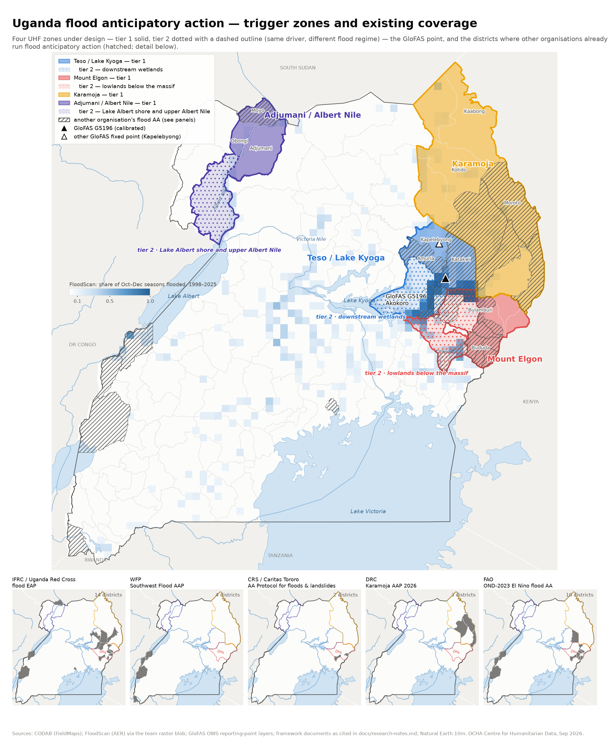
The four UHF zones under design, the GloFAS point, and where other organisations' flood anticipatory action already operates.
At a glance#
What each zone is for, what would trigger it, and whether the satellite backstop can be trusted there.
| Zone | Flooding regime | Proposed forecast | Backstop (FloodScan, read as percentiles of each district's own record) | Recorded impact 1998–2025 in these districts |
|---|---|---|---|---|
| Teso / Lake Kyoga tier 1 | Riverine — Akokoro river (Katakwi, Amuria, Kapelebyong) | good the IFRC/URCS EAP trigger as the IBF portal runs it (GloFAS 5-yr, ≥60 % of members, ≤5 d)Relationship drifted after 2013; needs a gauge or Flood Hub cross-check. | yes all 3 districts usable; 79 % of events reach the district's top fifth, against 42 % of arbitrary windows. Rainfall OR-leg adds nothing (slow riverine) | 2007 Teso floods, 2010, 2014 |
| Teso / Lake Kyoga tier 2 | Wetland fill downstream — Awoja / Lake Bisina (Soroti, Ngora, Serere) | promising, unvalidated Same G5196 signal 3–4 weeks later, or observed extentLagged link is weaker; may end up observation-led. | yes all 3 districts usable; 68 % of events in the top fifth, against 36 % by chance | 2007, 2012 Soroti |
| Mount Elgon tier 1 | Flash floods and landslides on the slopes (9 districts) | weak Rainfall forecast + antecedent wetness, 1–5 d leadPrecision under 15 % at any threshold; readiness-tier only. A partner plan for the sub-region is in draft — coordinate rather than duplicate. | partial mixed: 4 of 9 districts usable (Bulambuli, Kapchorwa, Manafwa, Mbale). Bududa, Bukwo and Kween are always zero, Sironko's floods do not land high, and Namisindwa has one dated event. Needs the observed-rainfall OR-leg (+17 pts) and gauges where the satellite fails | 2010 Nametsi, 2019 Bududa, Nov 2024 Bulambuli |
| Mount Elgon tier 2 | Lowland riverine and wetland — Manafwa / Mpologoma / Awoja (Butaleja, Pallisa, Kumi, Bukedea, Budaka, Kibuku) | promising, unvalidated Lagged Elgon rainfall, or observation-led; GloFAS Manafwa point failsForecast leg untested; observation is the strong leg. | yes 4 of 6 districts usable (Budaka and Kumi sit at chance); 72 % of events in the top fifth against 41 %, exposure AUC 0.92. Rainfall OR-leg adds +18 pts on major events | 2018 Butaleja, 2025 Pallisa, 2007 |
| Karamoja tier 1 | Flash floods (9 districts) | weak Rainfall forecast + antecedent wetness, 1–5 d lead; sub-zone by basinSame limits as the Elgon slopes; DRC covers Moroto, Napak, Amudat. | partial 4 of 9 districts usable (Abim, Amudat, Kotido, Nakapiripirit); across the zone 50 % of events reach the top fifth against 43 % by chance, and year-level AUC is near chance; for major events the observed-rainfall OR-leg is the leg that works (+31 pts) | 2007, 2008, 2018 Napak |
| Adjumani / Albert Nile tier 1 | Albert Nile bank — lake backwater and local tributary flash floods (Adjumani, Moyo, Obongi) | promising, unvalidated Lake Victoria → Kyoga → Albert level chain (months of lead); rainfall for the flash regimeThree lake-driven events on record; Albert altimetry starts 2016. | no 0 of 3 districts usable: 3 % of events reach the top fifth, against 29 % of arbitrary windows. Needs a river gauge (Pakwach, Laropi) or reports | 2020 Obongi, Oct–Nov 2023 Moyo, 2007 |
| Adjumani / Albert Nile tier 2 | Lake Albert shore and upper Albert Nile backwater (Pakwach, Nebbi, Madi Okollo) | promising, unvalidated Lake Albert level, same upstream chainCleanest lake-level case, few events to validate on. | no 0 of 3 districts usable: 10 % of events reach the top fifth, against 29 % by chance. CEMS confirms lakeshore floods are invisible to FloodScan | 2020 Pakwach (100k), 2009 Nebbi |
Forecast: good validated signal with usable lead time · promising, unvalidated real signal, too few events or too short a record to calibrate · weak readiness-tier at best, high false-alarm rate. Backstop: yes most recorded events register · partial a minority register, or the signal is year-level rather than event-level · no recorded floods sit no higher in the record than chance. Every zone also has the option of an observed-rainfall OR-leg (rain already fallen, over its return-period level) alongside the satellite, tested on the results page. Impact bars are scaled to the largest tier (Elgon slopes); they show what a trigger in that geography could in principle have been for, not what it would have caught — event totals split evenly across the districts named, all sources (see results page).
Districts in each zone#
What the tiers mean. A zone is one driver of flooding — one river, one massif, one lake system. Within a zone the water can still arrive in two different ways, and the two need different indicators, so each zone is split.
- Tier 1 is what the zone is for: the districts where the driver acts directly, and where the trigger is designed. Teso tier 1 is the reach the gauge actually measures; the Elgon slopes are where the rain falls and the hillsides fail; the Albert Nile bank is where the river tops out.
- Tier 2 is the same driver arriving differently, and therefore read differently: the Awoja and Bisina wetlands fill three to four weeks after the gauge peaks; the Elgon lowlands flood slowly for days after the rain that triggered the landslides above them; the Lake Albert shore floods on lake stand rather than on rain. Tier 2 is not a lower priority — the Elgon lowlands carry more recorded impact than Teso tier 1, and are the only Elgon districts where the satellite backstop works.
The split is drawn from evidence, not geography. Teso was settled by correlating GloFAS discharge at the G5196 point against each district’s observed flood extent: direct at lag 0 in tier 1, a 19–30 day lag in tier 2, and thirteen districts ruled out entirely. Elgon was split after the impact record showed every lowland flood year is also a slope flood year, while the flood regime, the satellite’s ability to see it and the usable indicator all differ between them. Adjumani was split because the record contains two distinct regimes, lake backwater with months of lead and local tributary flash floods with none.
| Zone and tier | Districts | Which |
|---|---|---|
| Teso / Lake Kyoga tier 1 | 3 | AmuriaKapelebyong†‡Katakwi |
| Teso / Lake Kyoga tier 2 · downstream wetlands (Awoja / Bisina) | 3 | NgoraSerere*‡Soroti |
| Mount Elgon tier 1 | 9 | Bududa*Bukwo*BulambuliKapchorwaKween*ManafwaMbaleNamisindwa†Sironko* |
| Mount Elgon tier 2 · lowlands below the massif (Manafwa / Mpologoma / Awoja) | 6 | Budaka*BukedeaButalejaKibukuKumi*Pallisa |
| Karamoja tier 1 | 9 | AbimAmudatKaabong*Karenga†KotidoMoroto*Nabilatuk†NakapiripiritNapak |
| Adjumani / Albert Nile tier 1 | 3 | Adjumani*Moyo*Obongi |
| Adjumani / Albert Nile tier 2 · Lake Albert shore and upper Albert Nile | 3 | Madi Okollo†Nebbi*Pakwach* |
36 districts in total, of Uganda's 135. Names follow the CODAB admin-2 vintage used throughout (FieldMaps). Markers flag districts where the evidence is thinner than their neighbours’, so they warrant care in targeting — * recorded floods there do not reach the district’s own top fifth of FloodScan days any more often than arbitrary windows do, or the series is too flat to threshold at all, so the observational backstop has little to work with; † fewer than three years carry a recorded impact, so nothing can be validated either way; ‡ in Teso only, G5196 discharge correlates under 0.30 with that district’s observed flooding. Computed from the results-page analyses.
The zones#
Teso / Lake Kyoga (riverine, IFRC/URCS EAP trigger)#
Regime: riverine. Second tier: downstream wetlands (Awoja / Bisina) — wetland fill, 3-4 weeks behind the gauge.
Ruled OUT by the coverage check (corr < 0.45 or P < 0.25): Kumi, Bukedea, Pallisa, Butaleja, Kibuku, Budaka, Butebo (Mpologoma system), Kaberamaido, Kalaki, Amolatar, Dokolo, Otuke, Alebtong (Kyoga north shore). Their flooding is not what G5196 sees.
Mount Elgon (flash floods & landslides)#
Regime: flash-landslide. Second tier: lowlands below the massif (Manafwa / Mpologoma / Awoja) — riverine + wetland, lagged behind the slope rainfall.
Slopes: rainfall-forecast trigger; FloodScan cannot see the hazard, impact record must be report-based. Lowlands: observed extent, river level, or Elgon rainfall with a lag.
Karamoja (flash floods)#
Regime: flash.
Rainfall-forecast trigger over a very large area; sub-zoning by river basin likely needed.
Adjumani / Albert Nile#
Regime: riverine-lake. Second tier: Lake Albert shore and upper Albert Nile — lake backwater (months of lead from Lake Victoria).
Two regimes in the record: lake backwater (2020, 2021, 2024 at >90th pctl Kyoga/Albert level) and local tributary flash floods at ordinary lake levels. Needs a lake-level leg and a rainfall leg.
GloFAS G5196 (Akokorio at Uganda gauge, river Akokoro) — LISFLOOD v4 pixel 1.775°N 33.875°E, calibrated on a 22-year record. The pixel is the local Akokoro above the Awoja confluence (mean ~7 m³/s), not the Karamoja-fed main stem. There are no GloFAS points on the Albert Nile.
Other organisations' flood anticipatory action#
What each covers and how it triggers, from the source documents named in each row. Karamoja drought plans (WFP/FAO PRO-ACT) are not flood frameworks and are not drawn.
IFRC / Uganda Red Cross — flood EAP (EAP2021UG01) — 14 high-risk districts#
Districts: Kasese, Ntoroko, Katakwi, Amuria, Kumi, Ngora, Nabilatuk, Butaleja, Sironko, Bududa, Manafwa, Bulambuli, Moyo, Kampala
Trigger: GloFAS via the 510 IBF portal: >=70% (operationally 60%) probability of a 5-yr RP flood in high-priority districts (10-yr in lower-priority), >1,000 households, 5-day lead, FAR<=0.5. As the portal computes it: each district, county and sub-county judged at its largest river cell (zonal max of forecast flow vs zonal max of the official 5-yr map); a triggered sub-area triggers its district (analysis/ifrc_reproduction.py)
Status: Approved 27 May 2021, 5-yr EAP nominally expired mid-2026 (GO appeal MDRUG048 open to 2026-11-30); no second-generation EAP found. One activation: 15 Nov 2023 (Ntoroko, Butaleja, Kikuube).
Source: EAP summary https://adore.ifrc.org/Download.aspx?FileId=438600 (p.3 district list); MDRUG048 reports
The '16 potentially exposed districts' in the Nov 2023 reports are that event's IBF output, not the design list.
No public assignment of districts to the 5-yr vs 10-yr priority tiers.
Nov 2023 lessons: multiple false alarms in the 2023 El Nino season; episodic floods not captured by the portal.
WFP — Southwest Flood AAP (Kasese, Ntoroko, Kisoro, Bundibugyo), Aug 2026-Dec 2028#
Districts: Kasese, Ntoroko, Kisoro, Bundibugyo
Trigger: Three-tier (mild/moderate/severe). General readiness: monthly SPI-1 forecast over per-district 3-yr (moderate) / 5-yr (severe) RP thresholds, MAM and SOND, 15 days-1 month lead. Readiness: 7-day 'exceptional rainfall' forecast at the 90th/95th/99th percentile OR daily totals above per-district mm thresholds (e.g. Kasese 14/39/47 mm, Ntoroko 16/27/35 mm for SOND), 7-day lead. Activation: the same exceeded on 2 consecutive forecast days, 5-day lead.
Status: Plan dated 28 Aug 2026, validity Aug 2026-Dec 2028; tier-1 beneficiaries 74,815-103,550 by scenario, budget USD 2.47-3.42 M. Earlier: 2024 MAM desilting, 2025 anticipatory cash (mainly Ntoroko).
Source: Flood Anticipatory Action Plan for Southwestern Uganda, WFP, 28 Aug 2026 (country team share; dev blob raw/external_frameworks/)
WFP/FAO PRO-ACT in the 9 Karamoja districts + Kaberamaido, Katakwi is a DROUGHT AA plan (activated May 2026) with multi-hazard bulletins — no flood trigger; not drawn on the flood map.
Rainfall thresholds are in mm/day within a 7-day forecast; the forecast product is not named in the plan summary.
A joint plan funded by the Uganda Humanitarian Fund (WFP, FAO, URCS, ACF) covers the same four districts for October-December 2026 (draft, Sep 2026; details on the restricted partner page).
CRS / Caritas Tororo — AA Protocol for floods & landslides, Butaleja + Bududa (validated 7 Jul 2026)#
Districts: Butaleja, Bududa
Trigger: Window 1 (1-month lead): DMS/UNMA seasonal forecast 'likely or very likely' above-normal rainfall for Mt Elgon. Window 2 (7-day lead): DMS forecast of >=70% probability of a 5-yr RP flood via the DMS emergency dashboard and/or VDMC community indicators (3 days above-average rain, W-E wind, animal movement, river turning brown) in Buwali sub-county (Bududa) and Butaleja Town Council.
Status: Validated V5, 7 Jul 2026; pilot budget USD 218,520 (USD 200,000 CRS internal HRD funding pre-arranged; Start Network a possible top-up) (ECHO-consortium lineage: Oxfam Novib lead, CRS, Caritas Tororo, URCS in Bududa, Butaleja, Mbale, Namisindwa, Sironko; AA first triggered by the UNMA OND-2023 El Nino outlook). Sub-county scope: Butaleja TC, Butaleja SC, Himutu, Mazimasa; Bududa Buwali, Bundesi, Busiriwa, Bubita, Bufuma, Bushiyi, Bukibokolo.
Source: Anticipatory Action Protocol for Floods and Landslides, Uganda / Butaleja and Bududa, Validated V5 (country team share; dev blob raw/external_frameworks/)
Threshold set by expert judgement, not a hindcast; MPCA via mobile money.
DRC — Karamoja AAP 2026 (drought, conflict, flash flood) — Moroto, Napak, Amudat#
Districts: Moroto, Napak, Amudat
Trigger: Flash-flood ladder: Kospir River at 80-85% and rising; ~150 mm forecast over a short window; livestock moving to high ground. Drought: SPI <= -1.5, Kobebe dam <50%, body condition <3.0, price falls >30%. Conflict: herd concentration, raiding, youth grouping.
Status: Activated 27 Jul 2026 on the dual drought + conflict trigger (not flood). Cross-border with Kenya (Loima, Lokiriama, North Pokot). Flood-risk analysis flags Napak floodplains as highest risk; 48,000 people forecast displaced by flooding in Uganda under DRC's OND 2026 central scenario.
Source: DRC Karamoja Anticipatory Action Plan AAP2026KS (country team share; dev blob raw/external_frameworks/)
FAO — OND-2023 El Nino flood AA (one-off, closed)#
Districts: Mbale, Butaleja, Sironko, Bulambuli, Manafwa, Namisindwa, Bundibugyo, Ntoroko, Kasese, Katakwi
Trigger: Seasonal outlook (OND 2023, 40-45% above-normal) — one-off, no standing threshold
Status: 11 Aug - 31 Dec 2023 only (OSRO/UGA/070/BEL, USD 1M, 78,375 people). Succeeded in 2025-26 by the Japan-funded OPM/FAO flood early-warning project (see PROGRAMMES), which is infrastructure rather than a trigger. FAO's standing AA in Uganda remains Karamoja drought/livestock, activated May 2026.
Source: FAO project report https://openknowledge.fao.org/server/api/core/bitstreams/22e1fbf6-6ae8-436c-9118-12d9d94482f6/content pp.1-2, 7
The only flood trigger documented in public sources for Uganda is the URCS/IFRC one. A partner draft covering the Mt Elgon sub-region exists but is unpublished, so it is held internally and is deliberately not described here; see docs/research-notes.md.
National and sub-regional programmes#
These carry no district list, so they are not on the map, but they change what a trigger can lean on — gauges to read, warning centres to route through, money to draw on.
FAO + Office of the Prime Minister (Government of Japan funded) — Enhancing Flood Management in Uganda with Integrated Early Warning Systems#
Scope: Rwenzori and Mount Elgon sub-regions (district list not published)
What it is: USD 1.13 M. Installed 10 hydro-climatic stations and 2 flood early-warning centres, issued 72 bulletins, reached 100,000+ people, trained 540, and delivered anticipatory actions to ~5,000 households. No trigger: this is early-warning infrastructure and community preparedness.
Status: Mar 2025 - Mar 2026, closed; results dialogue at OPM Jun 2026
Source: allAfrica, 5 Jun 2026 https://allafrica.com/stories/202606050689.html
Why it matters here: The 10 stations sit in the two sub-regions where our Elgon tier 1 has no event-level satellite signal and needs a gauge- or report-based backstop, and they are the obvious observation layer for any rainfall- or soil-moisture-based trigger on the slopes. Ask FAO/OPM whether the readings are accessible and at what latency.
Government of Uganda / OPM, with WFP, FAO and IGAD — National AA Roadmap 2026-2031 and the U-MHIEWS multi-hazard early-warning system#
Scope: National, with sub-national multi-hazard early-warning centres in Karamoja, Teso, Mount Elgon and Rwenzori, plus 2 regional centres
What it is: Commits to 'establish clear disaster triggers'; none published yet. Reports 1.6 M families reached with early warning and 400,000+ households with anticipatory action since 2021.
Status: Launched Jul 2026
Source: https://reliefweb.int/report/uganda/uganda-roadmap-anticipatory-action-2026-2031
Why it matters here: Three of our four zones (Teso, Mount Elgon, Karamoja) will have a government early-warning centre; West Nile will not. Those centres are the natural route for dissemination and for co-owning triggers.
FAO and WFP — Joint El Nino anticipatory action appeal#
Scope: 22 countries including Uganda; no sub-national detail published
What it is: USD 202 M for 8.8 M people
Status: Open, Jun 2026 - Mar 2027
Source: FAO newsroom, 18 Jun 2026
Why it matters here: A possible co-financing route for an OND 2026 activation; Uganda's share is not public.
Government of Uganda — national Disaster Risk Financing / Anticipatory Action Technical Working Group — The coordination body every Uganda AA framework reports into#
Scope: National
What it is: Members per the WFP South-West plan: DMS (met service), DWRM (water resources), OPM Department of Disaster Preparedness and Management, Ministries of Local Government, Finance, Agriculture, Water and Environment, the National Planning Authority, academia, FAO, URCS, World Vision and Action Against Hunger. WFP's plan routes post-activation trigger reviews (lead time, hits, false alarms, misses) through DWRM and DMS with WFP, FAO, URCS and OPM. CRS's protocol names URCS, FAO and WFP as members of the same group.
Status: Standing; convened the national AA dialogues of Nov 2022 and May 2024 and the 2026 roadmap
Source: WFP Southwest Flood AAP (Aug 2026) on institutional arrangements; CRS/Caritas protocol 2.1; CRS learning brief (Jul 2024)
Why it matters here: Any UHF trigger for Uganda should be tabled here, and the IFRC-form alignment for Teso is the natural opening. Note the WFP plan's own admission that 'limited information at lower administrative levels' constrains lead time and accuracy — the same gap our district-level analysis fills.
OPM with FAO, DRC and UNHCR — EWS, anticipatory action and ecosystem-based DRR needs assessment, refugee-hosting districts#
Scope: 13 refugee-hosting districts incl. Adjumani, Obongi, Madi Okollo, Yumbe, Terego
What it is: 92 responses, surveyed Dec 2025. Adjumani and Obongi report both riverine and flash flood exposure. Early-warning coverage is thin (Obongi ~20% institutional, Adjumani no institutional data) and the report states no comprehensive multi-hazard EWS is formally established in most of these districts.
Status: Preliminary report 7 Jan 2026; not published online (shared by the country team)
Source: Needs Assessment preliminary data analysis report, Jan 2026 (dev blob raw/country_team/uga/)
Why it matters here: Independent support for the two-regime split in the Adjumani zone, and a warning that the last mile there is weak — lead time must be budgeted for slow dissemination, favouring the long-lead lake-level leg.
Coverage against our zones#
- Teso / Kyoga: IFRC EAP (Katakwi, Amuria, Kumi, Ngora), FAO 2023 (Katakwi). No standing riverine trigger on the Akokoro/Awoja system. A government multi-hazard early-warning centre for Teso is coming under the national roadmap.
- Mount Elgon: the most crowded zone in the country, and an unpublished partner draft would add to it; IFRC EAP (Butaleja, Sironko, Bududa, Manafwa, Bulambuli); CRS/Caritas protocol at sub-county level in Butaleja and Bududa; FAO 2023. Kapchorwa, Kween, Bukwo, Namisindwa and Mbale have no trigger. Since 2025 the FAO/OPM project has put hydro-climatic stations and a flood early-warning centre in the sub-region — the most promising backstop for the slopes, where the satellite gives a year-level signal but not event detection.
- Karamoja: DRC (Moroto, Napak, Amudat — a flash-flood ladder inside a drought and conflict plan, activated Jul 2026 on the drought and conflict legs); Nabilatuk in the IFRC list. Kaabong, Karenga, Kotido, Abim and Nakapiripirit have no flood trigger. The FAO/WFP Karamoja drought plan activated separately in May 2026.
- Adjumani / Albert Nile: nothing except Moyo in the IFRC list — and no early-warning centre is planned for West Nile under the national roadmap. The OPM/FAO/UNHCR/DRC assessment finds early-warning coverage there among the thinnest in the country.
- Rwenzori (outside our zones): WFP's four-district plan, IFRC (Kasese, Ntoroko), and the other half of the FAO/OPM station network.
Harmonising triggers, area by area#
The same information organised by geography rather than by organisation, including the areas we are not proposing to cover. This is the view for the national Disaster Risk Financing and Anticipatory Action working group: who already triggers where, on what, and where two triggers point at the same districts with different instruments.
| Area | Existing triggers operating there | What we would add | Harmonisation note |
|---|---|---|---|
| Teso / Lake Kyoga 6 districts | IFRC / Uganda Red Cross — 3 of 6 districtsGloFAS ≥60–70 % of a 5-yr RP flood, >1,000 hh · 5 d FAO (closed) — 1 of 6 districtsseasonal outlook, one-off | the IFRC/URCS EAP trigger, adopted as it runs | Aligned by adopting IFRC’s trigger as the IBF portal computes it. It is not read at one reporting point: each district is judged at its largest river cell — the Akokoro for Amuria and Kapelebyong, the Lake Bisina–Awoja channel for Katakwi, Soroti and Ngora — and any triggered sub-county triggers its district. Nobody else operates here. |
| Mount Elgon — slopes 9 districts | IFRC / Uganda Red Cross — 4 of 9 districtsGloFAS ≥60–70 % of a 5-yr RP flood, >1,000 hh · 5 d CRS / Caritas Tororo — 1 of 9 districtsDMS seasonal outlook (1 mo) · DMS ≥70 % of a 5-yr RP flood or community indicators (7 d) FAO (closed) — 5 of 9 districtsseasonal outlook, one-off | rainfall + antecedent wetness, 1–5 d (readiness tier) | Several actors, one hazard, different instruments: CRS reads the DMS dashboard plus community indicators, IFRC applies GloFAS, which does not work here, and a partner plan for the sub-region is in draft. One rule with one owner would beat several, with FAO’s new station network as the shared observation layer. Sebei — Kapchorwa, Kween and Bukwo, 138k affected and 181 deaths on record — is in nobody’s plan. |
| Mount Elgon — lowlands 6 districts | IFRC / Uganda Red Cross — 2 of 6 districtsGloFAS ≥60–70 % of a 5-yr RP flood, >1,000 hh · 5 d CRS / Caritas Tororo — 1 of 6 districtsDMS seasonal outlook (1 mo) · DMS ≥70 % of a 5-yr RP flood or community indicators (7 d) FAO (closed) — 1 of 6 districtsseasonal outlook, one-off | observed extent; lagged Elgon rainfall | Butaleja alone is covered by IFRC, CRS and FAO, while Pallisa, Kumi, Bukedea, Budaka and Kibuku have nothing — and this is the tier where the satellite backstop actually works. The clearest rebalancing opportunity in the country. |
| Karamoja 9 districts | IFRC / Uganda Red Cross — 1 of 9 districtsGloFAS ≥60–70 % of a 5-yr RP flood, >1,000 hh · 5 d DRC — 3 of 9 districtsKospir River at 80–85 % and rising · ~150 mm forecast in 24–48 h | rainfall + antecedent wetness, 1–5 d | DRC covers three of nine districts with a local river gauge inside a drought and conflict plan; the FAO/WFP Karamoja plan is drought, a different hazard. Six districts have no flood trigger. DRC’s gauge-plus-forecast ladder is the model to extend rather than replace. |
| Adjumani / Albert Nile 6 districts | IFRC / Uganda Red Cross — 1 of 6 districtsGloFAS ≥60–70 % of a 5-yr RP flood, >1,000 hh · 5 d | lake-level chain (months of lead); rainfall for the flash regime | Only Moyo, through the IFRC list, and no early-warning centre is planned for West Nile under the national roadmap. No lake-level trigger exists anywhere in Uganda, so there is nothing to harmonise with: this is greenfield, and the design should be shared with the Nile Basin Initiative and DWRM rather than with the AA actors. |
| Rwenzori / South-West 6 districts | IFRC / Uganda Red Cross — 2 of 6 districtsGloFAS ≥60–70 % of a 5-yr RP flood, >1,000 hh · 5 d WFP — 4 of 6 districtsSPI-1 over a 3/5-yr RP (15–30 d) · 7-day rainfall at the 90/95/99th pctl or per-district mm (7 d) · same on 2 consecutive days (5 d) FAO (closed) — 3 of 6 districtsseasonal outlook, one-off | — outside our zones | The sharpest harmonisation case in the country, and not ours: WFP and IFRC both hold triggers over Kasese and Ntoroko with different instruments (percentile rainfall versus GloFAS) and different thresholds. Worth flagging to the DRF/AA working group even though we propose nothing here. |
| Kampala and central 1 district | IFRC / Uganda Red Cross — 1 of 1 districtsGloFAS ≥60–70 % of a 5-yr RP flood, >1,000 hh · 5 d | — outside our zones | IFRC only, for urban flash flooding. No overlap with our design. |
Districts per area are ours where we have a zone, and the conventional sub-region otherwise. Overlap counts are computed from the framework registry, so they cannot drift from the per-organisation sections above. Drought plans (FAO/WFP Karamoja, PRO-ACT) are excluded — different hazard. Partner plans still in draft are left out here; the version including them is on the restricted partner page.
Generated 2026-09-30 by pipeline/build_pages.py in
OCHA-DAP/ds-aa-uga-flooding. Work in progress — not a trigger.